Thank you for supporting this site ❤️
Make a donation
Make a donation
Gear up for your next adventure:
As an Amazon Associate, this site earns from qualifying purchases at no extra cost to you.
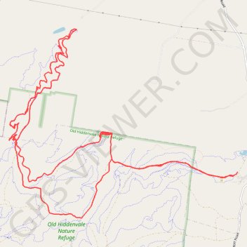
Old Hiddenvale Nature Refuge
#MTB #Loop #Hiddenvale
- Distance: 25.8 Km
- Elevation gain: 621 m
- Maximum elevation: 292 m
- Elevation loss: 611 m
- Minimum elevation: 125 m
Interactive trail map
Thank you for supporting this site ❤️
Make a donation
Make a donation
Gear up for your next adventure:
As an Amazon Associate, this site earns from qualifying purchases at no extra cost to you.
Trail profile
- Distance: 25.8 Km
- Elevation gain: 621 m
- Maximum elevation: 292 m
- Elevation loss: 611 m
- Minimum elevation: 125 m
Thank you for supporting this site ❤️
Make a donation
Make a donation
Gear up for your next adventure:
As an Amazon Associate, this site earns from qualifying purchases at no extra cost to you.
About this trail
Name: Old Hiddenvale Nature Refuge trail, distance, elevation, map, profile, GPS track
Start: Retreat, Grandchester, Greater Brisbane, Queensland, Australia (-27.71547 152.46663)
End: Retreat, Grandchester, Greater Brisbane, Queensland, Australia (-27.71625 152.46579)
Coordinates: -27.72488 152.41386 -27.68626 152.46664
Thank you for supporting this site ❤️
Make a donation
Make a donation
Gear up for your next adventure:
As an Amazon Associate, this site earns from qualifying purchases at no extra cost to you.