Make a donation
Gear up for your next adventure:
As an Amazon Associate, this site earns from qualifying purchases at no extra cost to you.
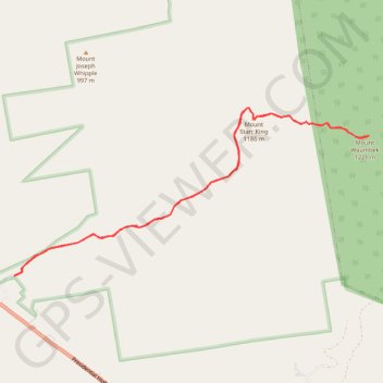
Mount Waumbek and Mount Starr King
Hike to Mount Waumbek and Mount Starr King via Starr King Trail and Kilkenny Ridge Trail in the White Mountain National Forest. #Hiking #Mountain #Nature #Forest
- Distance: 10.8 Km
- Elevation gain: 819 m
- Maximum elevation: 1,208 m
- Elevation loss: 820 m
- Minimum elevation: 484 m
- Moving time: 3 h 5 m
- Moving speed: 3.5 Km/h
- Maximum speed: 5.5 Km/h
- Total time: 3 h 24 m
- Global speed: 3.2 Km/h
Interactive trail map
Make a donation
Gear up for your next adventure:
As an Amazon Associate, this site earns from qualifying purchases at no extra cost to you.
Trail profile
- Distance: 10.8 Km
- Elevation gain: 819 m
- Maximum elevation: 1,208 m
- Elevation loss: 820 m
- Minimum elevation: 484 m
- Moving time: 3 h 5 m
- Moving speed: 3.5 Km/h
- Maximum speed: 5.5 Km/h
- Total time: 3 h 24 m
- Global speed: 3.2 Km/h
Make a donation
Gear up for your next adventure:
As an Amazon Associate, this site earns from qualifying purchases at no extra cost to you.
About this trail
Name: Mount Waumbek and Mount Starr King trail, distance, elevation, map, profile, GPS track
Start: Starr King Trail, Jefferson, Coös County, New Hampshire, 03583, United States (44.41850 -71.46678)
End: Starr King Trail, Jefferson, Coös County, New Hampshire, 03583, United States (44.41848 -71.46682)
Coordinates: 44.41848 -71.46682 44.43556 -71.41646
Make a donation
Gear up for your next adventure:
As an Amazon Associate, this site earns from qualifying purchases at no extra cost to you.
Other hiking, mountain biking, running and outdoor activity trails
Click on a trail to view its statistics, map and profile.