Import a GPX file

Buttermere - Lake District National Park

#Hiking #Loop

  • Distance: 6.9 Km
  • Elevation gain: 126 m
  • Maximum elevation: 154 m
  • Elevation loss: 129 m
  • Minimum elevation: 102 m

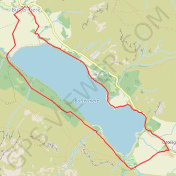
Interactive trail map

Trail profile

  • Distance: 6.9 Km
  • Elevation gain: 126 m
  • Maximum elevation: 154 m
  • Elevation loss: 129 m
  • Minimum elevation: 102 m

About this trail

Name: Buttermere - Lake District National Park trail, distance, elevation, map, profile, GPS track

Start: B5289, Buttermere, Cumberland, England, CA13 9UZ, United Kingdom (54.54131 -3.27599)

End: B5289, Buttermere, Cumberland, England, CA13 9UZ, United Kingdom (54.54131 -3.27635)

Coordinates: 54.52159 -3.28019 54.54131 -3.24633

Gear up for your next adventure:

🧥Packable Rain Jacket - Breathable waterproof layer for unpredictable weather
🧭GPS Tracker - Track your location in remote areas safely
🥾Mountain Hiking Boots - High-traction boots for rocky terrain
🧢Sun Protection Cap - Breathable cap to protect from sun exposure
🛶Canoe Life Vest - Safety vest for water sports

As an Amazon Associate, this site earns from qualifying purchases at no extra cost to you.