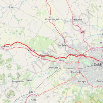
Royal canal way
#Bike
- Distance: 43.7 Km
- Elevation gain: 98 m
- Maximum elevation: 81 m
- Elevation loss: 163 m
- Minimum elevation: 10 m
Interactive trail map
Trail profile
- Distance: 43.7 Km
- Elevation gain: 98 m
- Maximum elevation: 81 m
- Elevation loss: 163 m
- Minimum elevation: 10 m
About this trail
Name: Royal canal way trail, distance, elevation, map, profile, GPS track
Coordinates: 53.36160 -6.83618 53.42977 -6.25845
Other hiking, mountain biking, running and outdoor activity trails
Click on a trail to view its statistics, map and profile.