Make a donation
Gear up for your next adventure:
As an Amazon Associate, this site earns from qualifying purchases at no extra cost to you.
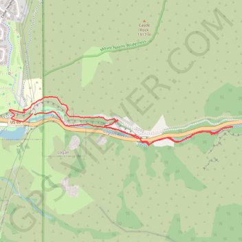
Logan Canyon Loop
Loop hike along Logan River from Ray Hugie Hydro Park via River Trail, Highline Trail and Bonneville Shoreline Trail. #Hiking #Loop #Nature #River #Canyon #Mountain #Forest #Park
- Distance: 5.0 Km
- Elevation gain: 148 m
- Maximum elevation: 1,499 m
- Elevation loss: 144 m
- Minimum elevation: 1,430 m
- Moving time: 58 m 59 s
- Moving speed: 5.1 Km/h
- Maximum speed: 7.3 Km/h
- Total time: 1 h 2 m
- Global speed: 4.8 Km/h
Interactive trail map
Make a donation
Gear up for your next adventure:
As an Amazon Associate, this site earns from qualifying purchases at no extra cost to you.
Trail profile
- Distance: 5.0 Km
- Elevation gain: 148 m
- Maximum elevation: 1,499 m
- Elevation loss: 144 m
- Minimum elevation: 1,430 m
- Moving time: 58 m 59 s
- Moving speed: 5.1 Km/h
- Maximum speed: 7.3 Km/h
- Total time: 1 h 2 m
- Global speed: 4.8 Km/h
Make a donation
Gear up for your next adventure:
As an Amazon Associate, this site earns from qualifying purchases at no extra cost to you.
About this trail
Name: Logan Canyon Loop trail, distance, elevation, map, profile, GPS track
Start: US 89, Hillcrest Neighborhood, Logan, Cache County, Utah, 84322, United States (41.74372 -111.78578)
Coordinates: 41.74121 -111.78853 41.74514 -111.76416
Make a donation
Gear up for your next adventure:
As an Amazon Associate, this site earns from qualifying purchases at no extra cost to you.
Other hiking, mountain biking, running and outdoor activity trails
Click on a trail to view its statistics, map and profile.
Highline Trail and Logan Canyon Gateway Trail loop
United States > Utah > Cache County > Logan
Distance: 5.8 Km • Elevation gain: 200 m • Maximum elevation: 1,540 m
Logan River Trail
United States > Utah > Cache County
Distance: 9.2 Km • Elevation gain: 150 m • Maximum elevation: 1,549 m
Bonneville Shoreline Trail
United States > Utah > Cache County > Logan
cycling, mtb
Distance: 9.3 Km • Elevation gain: 199 m • Maximum elevation: 1,554 m
2025-05-21_08-53_Wed
United States > Utah > Cache County > Logan
Canal Road and Canyon Road Loop Walk
Distance: 4.5 Km • Elevation gain: 78 m • Maximum elevation: 1,468 m
Make a donation
Gear up for your next adventure:
As an Amazon Associate, this site earns from qualifying purchases at no extra cost to you.