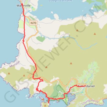
Waterville - Derrynane Beach - Caherdaniel
- Distance: 16.2 Km
- Elevation gain: 439 m
- Maximum elevation: 243 m
- Elevation loss: 418 m
- Minimum elevation: 0 m
Interactive trail map
Trail profile
- Distance: 16.2 Km
- Elevation gain: 439 m
- Maximum elevation: 243 m
- Elevation loss: 418 m
- Minimum elevation: 0 m
About this trail
Name: Waterville - Derrynane Beach - Caherdaniel trail, distance, elevation, map, profile, GPS track
Coordinates: 51.75743 -10.17412 51.82814 -10.10019
Other hiking, mountain biking, running and outdoor activity trails
Click on a trail to view its statistics, map and profile.