Make a donation
Gear up for your next adventure:
As an Amazon Associate, this site earns from qualifying purchases at no extra cost to you.
Reiner Road is the worst
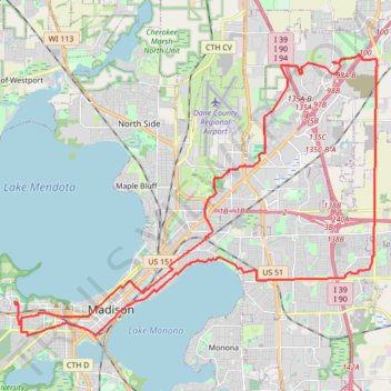
- Distance: 49.8 Km
- Elevation gain: 347 m
- Maximum elevation: 317 m
- Elevation loss: 332 m
- Minimum elevation: 260 m
- Moving time: 5 h 38 m
- Moving speed: 8.8 Km/h
- Maximum speed: 34.2 Km/h
- Total time: 7 h 50 m
- Global speed: 6.3 Km/h
Interactive trail map
Make a donation
Gear up for your next adventure:
As an Amazon Associate, this site earns from qualifying purchases at no extra cost to you.
Trail profile
- Distance: 49.8 Km
- Elevation gain: 347 m
- Maximum elevation: 317 m
- Elevation loss: 332 m
- Minimum elevation: 260 m
- Moving time: 5 h 38 m
- Moving speed: 8.8 Km/h
- Maximum speed: 34.2 Km/h
- Total time: 7 h 50 m
- Global speed: 6.3 Km/h
Make a donation
Gear up for your next adventure:
As an Amazon Associate, this site earns from qualifying purchases at no extra cost to you.
About this trail
Name: Reiner Road is the worst trail, distance, elevation, map, profile, GPS track
Coordinates: 43.06576 -89.42679 43.15707 -89.26562
Make a donation
Gear up for your next adventure:
As an Amazon Associate, this site earns from qualifying purchases at no extra cost to you.
Other hiking, mountain biking, running and outdoor activity trails
Click on a trail to view its statistics, map and profile.
Paoli via Southwest Bike Path, Badger State Trail and Military Ridge State Trail
United States > Wisconsin > Dane County > Madison
Distance: 43.3 Km • Elevation gain: 288 m • Maximum elevation: 323 m
Belleville via Southwest Bike Path and Badger State Trail
United States > Wisconsin > Dane County > Madison
Distance: 60.8 Km • Elevation gain: 354 m • Maximum elevation: 340 m