Thank you for supporting this site ❤️
Make a donation
Make a donation
Gear up for your next adventure:
As an Amazon Associate, this site earns from qualifying purchases at no extra cost to you.
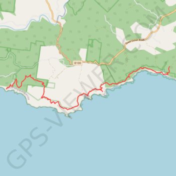
Great Ocean Walk - Milanesia Track - The Gables
Great Otway National Park. #Hiking #GreatOtway
- Distance: 15.9 Km
- Elevation gain: 752 m
- Maximum elevation: 166 m
- Elevation loss: 760 m
- Minimum elevation: 6 m
Interactive trail map
Thank you for supporting this site ❤️
Make a donation
Make a donation
Gear up for your next adventure:
As an Amazon Associate, this site earns from qualifying purchases at no extra cost to you.
Trail profile
- Distance: 15.9 Km
- Elevation gain: 752 m
- Maximum elevation: 166 m
- Elevation loss: 760 m
- Minimum elevation: 6 m
Thank you for supporting this site ❤️
Make a donation
Make a donation
Gear up for your next adventure:
As an Amazon Associate, this site earns from qualifying purchases at no extra cost to you.
About this trail
Name: Great Ocean Walk - Milanesia Track - The Gables trail, distance, elevation, map, profile, GPS track
Start: Melanesia Track, Yuulong, Shire of Colac Otway, Victoria, 3237, Australia (-38.74844 143.31877)
Coordinates: -38.76879 143.22049 -38.74844 143.31886
Thank you for supporting this site ❤️
Make a donation
Make a donation
Gear up for your next adventure:
As an Amazon Associate, this site earns from qualifying purchases at no extra cost to you.
Other hiking, mountain biking, running and outdoor activity trails
Click on a trail to view its statistics, map and profile.