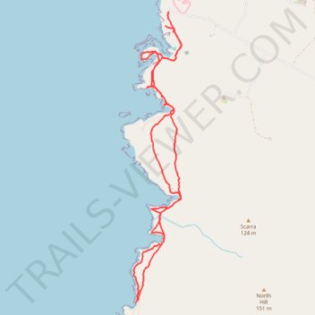
Yesnaby to North Gaulton Castle
- Distance: 8.1 Km
- Elevation gain: 340 m
- Maximum elevation: 58 m
- Elevation loss: 327 m
- Minimum elevation: 0 m
- Moving time: 2 h 47 m
- Moving speed: 2.9 Km/h
- Maximum speed: 5.2 Km/h
- Total time: 5 h 48 m
- Global speed: 1.4 Km/h
Interactive trail map
Trail profile
- Distance: 8.1 Km
- Elevation gain: 340 m
- Maximum elevation: 58 m
- Elevation loss: 327 m
- Minimum elevation: 0 m
- Moving time: 2 h 47 m
- Moving speed: 2.9 Km/h
- Maximum speed: 5.2 Km/h
- Total time: 5 h 48 m
- Global speed: 1.4 Km/h
About this trail
Name: Yesnaby to North Gaulton Castle trail, distance, elevation, map, profile, GPS track
Start: Yesnaby, Yesnaby Road, Orkney Islands, Scotland, United Kingdom (59.02370 -3.35934)
End: Yesnaby Road, Orkney Islands, Scotland, United Kingdom (59.02483 -3.35895)
Coordinates: 59.00072 -3.36461 59.02483 -3.35684
Other hiking, mountain biking, running and outdoor activity trails
Click on a trail to view its statistics, map and profile.
Hike from Skara Brae to Stromness
United Kingdom > Scotland > Orkney Islands
Distance: 16.3 Km • Elevation gain: 415 m • Maximum elevation: 111 m