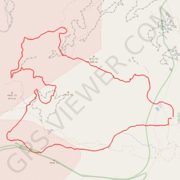
Import a GPX file

צופר- פוביצר

  • Distance: 42.8 Km
  • Elevation gain: 887 m
  • Maximum elevation: 359 m
  • Elevation loss: 892 m
  • Minimum elevation: 10 m

Interactive trail map

Trail profile

  • Distance: 42.8 Km
  • Elevation gain: 887 m
  • Maximum elevation: 359 m
  • Elevation loss: 892 m
  • Minimum elevation: 10 m

About this trail

Name: צופר- פוביצר trail, distance, elevation, map, profile, GPS track

Start: Zofar, Arava Tichona Regional Council, Beersheba Subdistrict, South District, Israel (30.56052 35.17059)

End: Zofar, Arava Tichona Regional Council, Beersheba Subdistrict, South District, Israel (30.56129 35.17170)

Coordinates: 30.54176 35.06645 30.61027 35.17176

Other hiking, mountain biking, running and outdoor activity trails

Click on a trail to view its statistics, map and profile.

Ramon to Sapir

Israel > South District > Ramat Negev Regional Council

מכתש רמון לספיר: ריצה חוצה מדבריות: מהר הנגב אל הערבה

Distance: 36.2 Km • Elevation gain: 856 m • Maximum elevation: 547 m

Gear up for your next adventure:

🧣Evaporative Cooling Towel - Beat the heat during intense summer climbs
🚲Heavy Duty Bike Lock - Secure your bike at the trailhead or during stops
🪑Ultralight Camping Stool - Compact seating for rest stops during long hikes
🧭GPS Handheld Device - Reliable GPS navigation for outdoor adventures
🚲MTB Frame Bag - Carry tools and maps directly on your bicycle frame

As an Amazon Associate, this site earns from qualifying purchases at no extra cost to you.