Make a donation
Gear up for your next adventure:
As an Amazon Associate, this site earns from qualifying purchases at no extra cost to you.
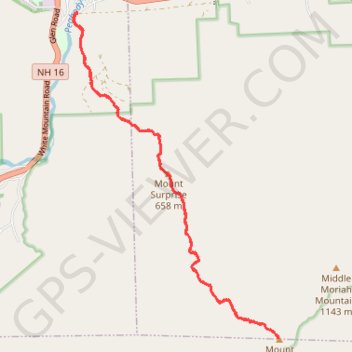
Mount Moriah
Hike from Peabody River to Mount Moriah via Carter-Moriah Trail and Mount Surprise in the White Mountain National Forest. #Hiking #Mountain #Forest #Nature #River
- Distance: 14.4 Km
- Elevation gain: 972 m
- Maximum elevation: 1,215 m
- Elevation loss: 972 m
- Minimum elevation: 242 m
- Moving time: 4 h 26 m
- Moving speed: 3.2 Km/h
- Maximum speed: 8.9 Km/h
- Total time: 5 h 4 m
- Global speed: 2.8 Km/h
Interactive trail map
Make a donation
Gear up for your next adventure:
As an Amazon Associate, this site earns from qualifying purchases at no extra cost to you.
Trail profile
- Distance: 14.4 Km
- Elevation gain: 972 m
- Maximum elevation: 1,215 m
- Elevation loss: 972 m
- Minimum elevation: 242 m
- Moving time: 4 h 26 m
- Moving speed: 3.2 Km/h
- Maximum speed: 8.9 Km/h
- Total time: 5 h 4 m
- Global speed: 2.8 Km/h
Make a donation
Gear up for your next adventure:
As an Amazon Associate, this site earns from qualifying purchases at no extra cost to you.
About this trail
Name: Mount Moriah trail, distance, elevation, map, profile, GPS track
Start: 43, Bangor Street, Gorham, Coös County, New Hampshire, 03581, United States (44.38330 -71.16863)
End: 43, Bangor Street, Gorham, Coös County, New Hampshire, 03581, United States (44.38329 -71.16859)
Coordinates: 44.34043 -71.16948 44.38331 -71.13176
Make a donation
Gear up for your next adventure:
As an Amazon Associate, this site earns from qualifying purchases at no extra cost to you.