Thank you for supporting this site ❤️
Make a donation
Make a donation
Gear up for your next adventure:
As an Amazon Associate, this site earns from qualifying purchases at no extra cost to you.
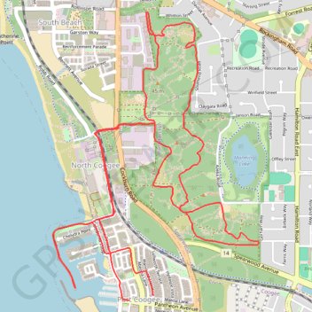
MAnning Park
- Distance: 11.8 Km
- Elevation gain: 181 m
- Maximum elevation: 46 m
- Elevation loss: 184 m
- Minimum elevation: 0 m
- Moving time: 48 m 28 s
- Moving speed: 14.7 Km/h
- Maximum speed: 40.8 Km/h
- Total time: 54 m 25 s
- Global speed: 13.1 Km/h
Interactive trail map
Thank you for supporting this site ❤️
Make a donation
Make a donation
Gear up for your next adventure:
As an Amazon Associate, this site earns from qualifying purchases at no extra cost to you.
Trail profile
- Distance: 11.8 Km
- Elevation gain: 181 m
- Maximum elevation: 46 m
- Elevation loss: 184 m
- Minimum elevation: 0 m
- Moving time: 48 m 28 s
- Moving speed: 14.7 Km/h
- Maximum speed: 40.8 Km/h
- Total time: 54 m 25 s
- Global speed: 13.1 Km/h
Thank you for supporting this site ❤️
Make a donation
Make a donation
Gear up for your next adventure:
As an Amazon Associate, this site earns from qualifying purchases at no extra cost to you.
About this trail
Name: MAnning Park trail, distance, elevation, map, profile, GPS track
Coordinates: -32.10235 115.75595 -32.08244 115.77268
Thank you for supporting this site ❤️
Make a donation
Make a donation
Gear up for your next adventure:
As an Amazon Associate, this site earns from qualifying purchases at no extra cost to you.
Other hiking, mountain biking, running and outdoor activity trails
Click on a trail to view its statistics, map and profile.