Make a donation
Gear up for your next adventure:
As an Amazon Associate, this site earns from qualifying purchases at no extra cost to you.
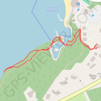
Walk from lodge to loch and back, Loch Insh
- Distance: 0.9 Km
- Elevation gain: 23 m
- Maximum elevation: 241 m
- Elevation loss: 23 m
- Minimum elevation: 220 m
- Moving time: 16 m 22 s
- Moving speed: 3.4 Km/h
- Maximum speed: 6.8 Km/h
- Total time: 34 m 35 s
- Global speed: 1.6 Km/h
Interactive trail map
Make a donation
Gear up for your next adventure:
As an Amazon Associate, this site earns from qualifying purchases at no extra cost to you.
Trail profile
- Distance: 0.9 Km
- Elevation gain: 23 m
- Maximum elevation: 241 m
- Elevation loss: 23 m
- Minimum elevation: 220 m
- Moving time: 16 m 22 s
- Moving speed: 3.4 Km/h
- Maximum speed: 6.8 Km/h
- Total time: 34 m 35 s
- Global speed: 1.6 Km/h
Make a donation
Gear up for your next adventure:
As an Amazon Associate, this site earns from qualifying purchases at no extra cost to you.
About this trail
Name: Walk from lodge to loch and back, Loch Insh trail, distance, elevation, map, profile, GPS track
Start: Insh Hall, B970, Kincraig, Highland, Scotland, PH21 1NF, United Kingdom (57.11560 -3.91961)
End: Insh Hall, B970, Kincraig, Highland, Scotland, PH21 1NF, United Kingdom (57.11564 -3.91964)
Coordinates: 57.11494 -3.92444 57.11618 -3.91955
Make a donation
Gear up for your next adventure:
As an Amazon Associate, this site earns from qualifying purchases at no extra cost to you.
Other hiking, mountain biking, running and outdoor activity trails
Click on a trail to view its statistics, map and profile.
Inshriach Forest
United Kingdom > Scotland > Highland > Kincraig
Navigating Nature's Obstacles: A Highland Adventure at Loch Insh
Distance: 18.1 Km • Elevation gain: 306 m • Maximum elevation: 343 m