Bell Rock Loop Trail in Munds Mountain Wilderness
The Bell Rock Loop Trail offers an unforgettable experience with its panoramic views of Sedona’s iconic red rock formations, including Bell Rock and Courthouse Butte. The trail is well-suited for all levels, offering a relatively short and easy hike, though the area is exposed to the sun. For those looking for a more adventurous experience, there are opportunities to scramble up Bell Rock itself, offering even more striking views of the surrounding landscape and the famous Sedona vortex energy. #Hiking #Mountain #Loop #Nature #Rock
- Distance: 3.1 Km
- Elevation gain: 74 m
- Maximum elevation: 1,356 m
- Elevation loss: 75 m
- Minimum elevation: 1,300 m
- Moving time: 47 m 59 s
- Moving speed: 3.9 Km/h
- Maximum speed: 5.7 Km/h
- Total time: 56 m 29 s
- Global speed: 3.3 Km/h
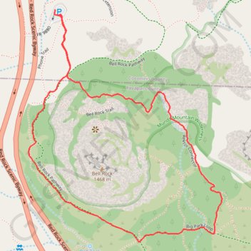
Interactive trail map
Trail profile
- Distance: 3.1 Km
- Elevation gain: 74 m
- Maximum elevation: 1,356 m
- Elevation loss: 75 m
- Minimum elevation: 1,300 m
- Moving time: 47 m 59 s
- Moving speed: 3.9 Km/h
- Maximum speed: 5.7 Km/h
- Total time: 56 m 29 s
- Global speed: 3.3 Km/h
About this trail
Name: Bell Rock Loop Trail in Munds Mountain Wilderness trail, distance, elevation, map, profile, GPS track
Start: FR 9880, Coconino County, Arizona, 86351, United States (34.80582 -111.76648)
Coordinates: 34.79764 -111.76781 34.80602 -111.75931
Other hiking, mountain biking, running and outdoor activity trails
Click on a trail to view its statistics, map and profile.
Bell Rock and Courthouse Butte Loop via Bell Rock Pathway and Big Park Loop
United States > Arizona > Yavapai County
The Bell Rock and Courthouse Butte Loop in Coconino National Forest offers hikers a scenic journey around two of the area's most iconic red rock formations, the distinctive Bell Rock, a dome-shaped butte, and the imposing Courthouse Butte. Along the well-marked trail, you'll encounter diverse desert flora,…
Distance: 6.8 Km • Elevation gain: 126 m • Maximum elevation: 1,365 m
Bell Rock Pathway to Upper Bell Rock Trail in Coconino National Forest
United States > Arizona > Yavapai County
The Bell Rock Pathway to Upper Bell Rock Trail in Coconino National Forest offers hikers a captivating journey through Sedona's iconic red rock formations. Along the route, you'll encounter panoramic vistas of Bell Rock and Courthouse Butte, with their distinctive red sandstone cliffs and spires. The trail…
Distance: 4.1 Km • Elevation gain: 117 m • Maximum elevation: 1,386 m