Lassen Peak Trail in Lassen Volcanic National Park
The Lassen Peak Trail offers a challenging yet rewarding ascent to the summit of Lassen Peak, providing breathtaking panoramic views of the surrounding landscape. As you make your way up, you'll experience dramatic changes in terrain, from dense forests to open, rocky sections above the treeline, with occasional sightings of wildlife such as chipmunks. From the summit, the vistas extend across the park, revealing distant snow-capped peaks, including Mount Shasta, and a close-up look at Lassen's volcanic terrain, complete with hydrothermal features like fumaroles and boiling springs in the valley below. #Hiking #Mountain #Forest #Nature #Volcano
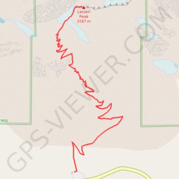
- Distance: 7.6 Km
- Elevation gain: 628 m
- Maximum elevation: 3,162 m
- Elevation loss: 629 m
- Minimum elevation: 2,584 m
Interactive trail map
Trail profile
- Distance: 7.6 Km
- Elevation gain: 628 m
- Maximum elevation: 3,162 m
- Elevation loss: 629 m
- Minimum elevation: 2,584 m
About this trail
Name: Lassen Peak Trail in Lassen Volcanic National Park trail, distance, elevation, map, profile, GPS track
Start: Lassen Peak Trail, Shasta County, California, United States (40.47489 -121.50572)
End: Lassen Peak Trail, Shasta County, California, United States (40.47469 -121.50593)
Coordinates: 40.47469 -121.50791 40.48817 -121.50073