Lighthouse Peak via Lighthouse Trail in Palo Duro Canyon State Park
The Lighthouse Trail in Palo Duro Canyon offers hikers a stunning journey through colorful desert landscapes, marked by vibrant reds, oranges, and yellows of the canyon walls. The route transitions from open plains with minimal shade to more rugged terrain, including dramatic gulches and towering rock formations. As you approach the iconic Lighthouse Peak, the steep final ascent offers both a challenge and reward, with expansive views of the canyon below. #Hiking #Rock #Canyon #Nature
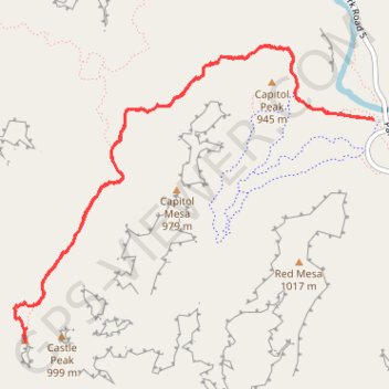
- Distance: 9.8 Km
- Elevation gain: 138 m
- Maximum elevation: 959 m
- Elevation loss: 139 m
- Minimum elevation: 862 m
- Moving time: 2 h 12 m
- Moving speed: 4.5 Km/h
- Maximum speed: 7.4 Km/h
- Total time: 2 h 36 m
- Global speed: 3.8 Km/h
Interactive trail map
Trail profile
- Distance: 9.8 Km
- Elevation gain: 138 m
- Maximum elevation: 959 m
- Elevation loss: 139 m
- Minimum elevation: 862 m
- Moving time: 2 h 12 m
- Moving speed: 4.5 Km/h
- Maximum speed: 7.4 Km/h
- Total time: 2 h 36 m
- Global speed: 3.8 Km/h
About this trail
Name: Lighthouse Peak via Lighthouse Trail in Palo Duro Canyon State Park trail, distance, elevation, map, profile, GPS track
Start: Lighthouse Trail, Randall County, Texas, United States (34.95126 -101.66823)
End: Capitol Peak Trail, Randall County, Texas, United States (34.95126 -101.66814)
Coordinates: 34.93623 -101.69766 34.95625 -101.66814
Other hiking, mountain biking, running and outdoor activity trails
Click on a trail to view its statistics, map and profile.
Lighthouse Peak via Lighthouse Trail in Palo Duro Canyon State Park
United States > Texas > Randall County
The Lighthouse Trail is a delightful and fairly easy hike with breathtaking views of vibrant cliffs and the iconic Lighthouse Peak. Most of the trail is flat and scenic, making it suitable for all skill levels, but the final steep section adds a fun challenge before reaching the spectacular summit. Start early…
Distance: 10.0 Km • Elevation gain: 147 m • Maximum elevation: 959 m