Broken Arrow Trail to Chicken Point in Coconino National Forest
The Broken Arrow Trail to Chicken Point is a captivating route in the heart of Sedona's famous red rock landscape. Along this hike, you'll be treated to expansive views of iconic formations like Twin Buttes and Gibraltar Rock, as well as the striking, colorful scenery typical of the area. Highlights include the eerie Devil's Dining Room Sinkhole, a notable geological feature, Mushroom Rock, and the panoramic vistas from Chicken Point, which offer a stunning payoff after a moderate, yet rewarding, trek. #Hiking #Rock #Forest #Nature
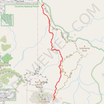
- Distance: 4.8 Km
- Elevation gain: 127 m
- Maximum elevation: 1,411 m
- Elevation loss: 127 m
- Minimum elevation: 1,308 m
- Moving time: 1 h 14 m
- Moving speed: 3.8 Km/h
- Maximum speed: 5.9 Km/h
- Total time: 1 h 19 m
- Global speed: 3.6 Km/h
Interactive trail map
Trail profile
- Distance: 4.8 Km
- Elevation gain: 127 m
- Maximum elevation: 1,411 m
- Elevation loss: 127 m
- Minimum elevation: 1,308 m
- Moving time: 1 h 14 m
- Moving speed: 3.8 Km/h
- Maximum speed: 5.9 Km/h
- Total time: 1 h 19 m
- Global speed: 3.6 Km/h
About this trail
Name: Broken Arrow Trail to Chicken Point in Coconino National Forest trail, distance, elevation, map, profile, GPS track
Coordinates: 34.82905 -111.75729 34.84558 -111.75288
Other hiking, mountain biking, running and outdoor activity trails
Click on a trail to view its statistics, map and profile.
Chicken Point via Little Horse Trail in Coconino National Forest
United States > Arizona > Coconino County > Sedona
The Little Horse Trail to Chicken Point in Sedona, Arizona, offers hikers a moderate journey through the region's distinctive red rock landscapes. Along the path, hikers can observe formations such as Cathedral Rock, Bell Rock, and the towering Two Nuns near Chicken Point. The trail is well-marked and suitable…
Distance: 6.1 Km • Elevation gain: 130 m • Maximum elevation: 1,395 m