Thank you for supporting this site ❤️
Make a donation
Make a donation
Gear up for your next adventure:
As an Amazon Associate, this site earns from qualifying purchases at no extra cost to you.
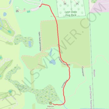
Lyon Oaks County Park Heron Rookery Viewing Area
- Distance: 1.0 Km
- Elevation gain: 6 m
- Maximum elevation: 290 m
- Elevation loss: 7 m
- Minimum elevation: 283 m
- Moving time: 13 m 31 s
- Moving speed: 4.5 Km/h
- Maximum speed: 6.5 Km/h
- Total time: 15 m 45 s
- Global speed: 3.9 Km/h
Interactive trail map
Thank you for supporting this site ❤️
Make a donation
Make a donation
Gear up for your next adventure:
As an Amazon Associate, this site earns from qualifying purchases at no extra cost to you.
Trail profile
- Distance: 1.0 Km
- Elevation gain: 6 m
- Maximum elevation: 290 m
- Elevation loss: 7 m
- Minimum elevation: 283 m
- Moving time: 13 m 31 s
- Moving speed: 4.5 Km/h
- Maximum speed: 6.5 Km/h
- Total time: 15 m 45 s
- Global speed: 3.9 Km/h
Thank you for supporting this site ❤️
Make a donation
Make a donation
Gear up for your next adventure:
As an Amazon Associate, this site earns from qualifying purchases at no extra cost to you.
About this trail
Name: Lyon Oaks County Park Heron Rookery Viewing Area trail, distance, elevation, map, profile, GPS track
Coordinates: 42.51208 -83.56147 42.51915 -83.55855
Thank you for supporting this site ❤️
Make a donation
Make a donation
Gear up for your next adventure:
As an Amazon Associate, this site earns from qualifying purchases at no extra cost to you.