Thank you for supporting this site ❤️
Make a donation
Make a donation
Gear up for your next adventure:
As an Amazon Associate, this site earns from qualifying purchases at no extra cost to you.
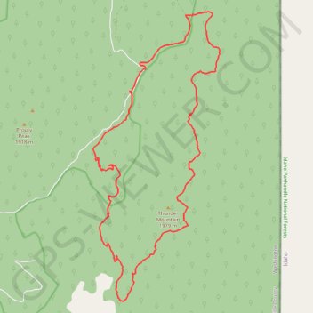
Thunder Mountain Loop
- Distance: 23.1 Km
- Elevation gain: 962 m
- Maximum elevation: 1,863 m
- Elevation loss: 960 m
- Minimum elevation: 1,265 m
- Moving time: 4 h 43 m
- Moving speed: 4.9 Km/h
- Maximum speed: 26.6 Km/h
- Total time: 6 h 12 m
- Global speed: 3.7 Km/h
Interactive trail map
Thank you for supporting this site ❤️
Make a donation
Make a donation
Gear up for your next adventure:
As an Amazon Associate, this site earns from qualifying purchases at no extra cost to you.
Trail profile
- Distance: 23.1 Km
- Elevation gain: 962 m
- Maximum elevation: 1,863 m
- Elevation loss: 960 m
- Minimum elevation: 1,265 m
- Moving time: 4 h 43 m
- Moving speed: 4.9 Km/h
- Maximum speed: 26.6 Km/h
- Total time: 6 h 12 m
- Global speed: 3.7 Km/h
Thank you for supporting this site ❤️
Make a donation
Make a donation
Gear up for your next adventure:
As an Amazon Associate, this site earns from qualifying purchases at no extra cost to you.
About this trail
Name: Thunder Mountain Loop trail, distance, elevation, map, profile, GPS track
Start: Forest Road 2220252, Pend Oreille County, Washington, United States (48.90157 -117.08231)
End: Forest Road 2220252, Pend Oreille County, Washington, United States (48.90139 -117.08213)
Coordinates: 48.85540 -117.09456 48.91898 -117.05219
Thank you for supporting this site ❤️
Make a donation
Make a donation
Gear up for your next adventure:
As an Amazon Associate, this site earns from qualifying purchases at no extra cost to you.