Thank you for supporting this site ❤️
Make a donation
Make a donation
Gear up for your next adventure:
As an Amazon Associate, this site earns from qualifying purchases at no extra cost to you.
Wungong Gorge
Interactive trail map
Thank you for supporting this site ❤️
Make a donation
Make a donation
Gear up for your next adventure:
As an Amazon Associate, this site earns from qualifying purchases at no extra cost to you.
Trail profile
- Distance: 14.9 Km
- Elevation gain: 621 m
- Maximum elevation: 264 m
- Elevation loss: 621 m
- Minimum elevation: 57 m
Thank you for supporting this site ❤️
Make a donation
Make a donation
Gear up for your next adventure:
As an Amazon Associate, this site earns from qualifying purchases at no extra cost to you.
About this trail
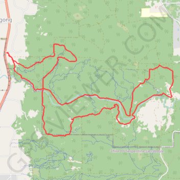
Name: Wungong Gorge trail, distance, elevation, map, profile, GPS track
Start: Rails Crescent, Wungong, City Of Armadale, Western Australia, 6122, Australia (-32.18928 116.01574)
End: Rails Crescent, Wungong, City Of Armadale, Western Australia, 6122, Australia (-32.18928 116.01574)
Coordinates: -32.20542 116.01574 -32.18756 116.05385
Thank you for supporting this site ❤️
Make a donation
Make a donation
Gear up for your next adventure:
As an Amazon Associate, this site earns from qualifying purchases at no extra cost to you.