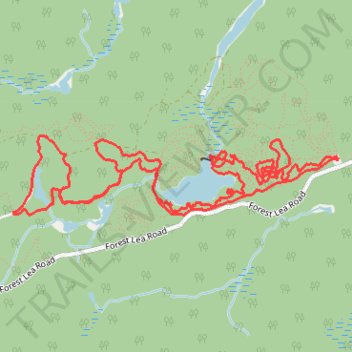
Forest Lea Trails
- Distance: 10.7 Km
- Elevation gain: 119 m
- Maximum elevation: 196 m
- Elevation loss: 120 m
- Minimum elevation: 168 m
- Moving time: 1 h 19 m
- Moving speed: 8.0 Km/h
- Maximum speed: 33.9 Km/h
- Total time: 1 h 19 m
- Global speed: 8.0 Km/h
Interactive trail map
Trail profile
- Distance: 10.7 Km
- Elevation gain: 119 m
- Maximum elevation: 196 m
- Elevation loss: 120 m
- Minimum elevation: 168 m
- Moving time: 1 h 19 m
- Moving speed: 8.0 Km/h
- Maximum speed: 33.9 Km/h
- Total time: 1 h 19 m
- Global speed: 8.0 Km/h
About this trail
Name: Forest Lea Trails trail, distance, elevation, map, profile, GPS track
Coordinates: 45.80532 -77.30669 45.81029 -77.27743
Topography: Laurentian Valley topographic map, elevation, terrain
Other hiking, mountain biking, running and outdoor activity trails
Click on a trail to view its statistics, map and profile.
Hike on the Forest Lea trails
Canada > Ontario > Renfrew County > Laurentian Valley
Distance: 8.2 Km • Elevation gain: 78 m • Maximum elevation: 204 m
Hiking Forest Lea trails
Canada > Ontario > Renfrew County > Laurentian Valley
Distance: 7.2 Km • Elevation gain: 51 m • Maximum elevation: 186 m
Forest Lea trails
Canada > Ontario > Renfrew County > Laurentian Valley
Distance: 4.0 Km • Elevation gain: 41 m • Maximum elevation: 185 m