Import a GPX file

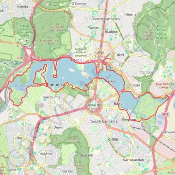
Canberra - Lake Burley Griffin

#Hiking #Bike #Loop #Canberra

  • Distance: 36.9 Km
  • Elevation gain: 302 m
  • Maximum elevation: 583 m
  • Elevation loss: 306 m
  • Minimum elevation: 551 m

Interactive trail map

Trail profile

  • Distance: 36.9 Km
  • Elevation gain: 302 m
  • Maximum elevation: 583 m
  • Elevation loss: 306 m
  • Minimum elevation: 551 m

About this trail

Other hiking, mountain biking, running and outdoor activity trails

Click on a trail to view its statistics, map and profile.

Majura Mountain Loop

Australia > Canberra

#Bike #Loop #Majura #Canberra

Distance: 29.1 Km • Elevation gain: 252 m • Maximum elevation: 687 m

Shell Cove - Duffy

Australia > New South Wales

#Bike #Canberra

Distance: 292.2 Km • Elevation gain: 3,534 m • Maximum elevation: 872 m

Cloudride24.FINAL

Australia > North Canberra

Distance: 1,028.8 Km • Elevation gain: 21,282 m • Maximum elevation: 1,754 m

Gear up for your next adventure:

🦟Insect Repellent - Keep mosquitoes and black flies away in wooded areas
🧼Travel Hand Sanitizer - Keep hands clean when water is scarce
🥾Trekking Boots - Durable boots for long-distance trekking
🥾Waterproof Hiking Boots - Essential footwear for rugged terrain and wet Canadian trails
🧰Survival Kit - Essential gear for emergencies in the wilderness

As an Amazon Associate, this site earns from qualifying purchases at no extra cost to you.