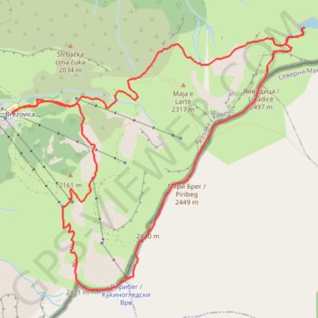
Livadicko Ezero, Livadički Vrv, Piribreg, Piribeg (From Brez...
- Distance: 13.0 Km
- Elevation gain: 1,034 m
- Maximum elevation: 2,508 m
- Elevation loss: 1,034 m
- Minimum elevation: 1,728 m
- Moving time: 5 h 12 m
- Moving speed: 2.5 Km/h
- Maximum speed: 5.6 Km/h
- Total time: 8 h 20 m
- Global speed: 1.6 Km/h
Interactive trail map
Trail profile
- Distance: 13.0 Km
- Elevation gain: 1,034 m
- Maximum elevation: 2,508 m
- Elevation loss: 1,034 m
- Minimum elevation: 1,728 m
- Moving time: 5 h 12 m
- Moving speed: 2.5 Km/h
- Maximum speed: 5.6 Km/h
- Total time: 8 h 20 m
- Global speed: 1.6 Km/h
About this trail
Name: Livadicko Ezero, Livadički Vrv, Piribreg, Piribeg (From Brez... trail, distance, elevation, map, profile, GPS track
Coordinates: 42.16530 21.03477 42.19050 21.07276
Other hiking, mountain biking, running and outdoor activity trails
Click on a trail to view its statistics, map and profile.
2022_Yu
Slovenia > Ajdovščina > Žapuže
Distance: 2,457.3 Km • Elevation gain: 32,048 m • Maximum elevation: 1,950 m