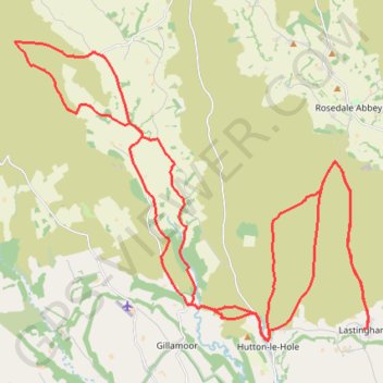
Lastingham MTB Loop
- Distance: 44.2 Km
- Elevation gain: 1,046 m
- Maximum elevation: 370 m
- Elevation loss: 1,046 m
- Minimum elevation: 80 m
- Moving time: 3 h 23 m
- Moving speed: 13.0 Km/h
- Maximum speed: 47.5 Km/h
- Total time: 3 h 55 m
- Global speed: 11.3 Km/h
Interactive trail map
Trail profile
- Distance: 44.2 Km
- Elevation gain: 1,046 m
- Maximum elevation: 370 m
- Elevation loss: 1,046 m
- Minimum elevation: 80 m
- Moving time: 3 h 23 m
- Moving speed: 13.0 Km/h
- Maximum speed: 47.5 Km/h
- Total time: 3 h 55 m
- Global speed: 11.3 Km/h
About this trail
Name: Lastingham MTB Loop trail, distance, elevation, map, profile, GPS track
Coordinates: 54.30175 -1.01554 54.36863 -0.87999
Other hiking, mountain biking, running and outdoor activity trails
Click on a trail to view its statistics, map and profile.
Hartoft End Loop
United Kingdom > England > North Yorkshire > Rosedale Abbey
Distance: 20.7 Km • Elevation gain: 499 m • Maximum elevation: 372 m
Sinnington MTB loop
United Kingdom > England > North Yorkshire > Sinnington
Distance: 22.8 Km • Elevation gain: 464 m • Maximum elevation: 276 m
Rosedale Abbey north loop to Fryup Dale
United Kingdom > England > North Yorkshire > Rosedale Abbey
Distance: 31.9 Km • Elevation gain: 701 m • Maximum elevation: 422 m
Gillamoor loop walk
United Kingdom > England > North Yorkshire > Gillamoor
Distance: 8.8 Km • Elevation gain: 185 m • Maximum elevation: 212 m
Gillamoor MTB Loop
United Kingdom > England > North Yorkshire > Gillamoor
Distance: 14.2 Km • Elevation gain: 374 m • Maximum elevation: 314 m
St Gregory's loop
United Kingdom > England > North Yorkshire > Helmsley
Distance: 30.5 Km • Elevation gain: 525 m • Maximum elevation: 294 m
Hartoft Rigg
United Kingdom > England > North Yorkshire > Rosedale Abbey
Distance: 9.4 Km • Elevation gain: 255 m • Maximum elevation: 287 m
Farndale
United Kingdom > England > North Yorkshire > Appleton-le-Moors
Ryedale Mountain Biking
Distance: 52.9 Km • Elevation gain: 1,251 m • Maximum elevation: 407 m