
Five Mile Camp via Duckabush Trail in the The Brothers Wilderness
The journey to Five Mile Camp via the Duckabush Trail in The Brothers Wilderness offers a rich exploration of natural beauty. The route begins with a gentle climb through lush, moss-laden forests, passing along the Duckabush River with its serene cascades and occasional clearings that showcase striking views of the surrounding valley. As hikers progress, the trail becomes steeper, especially around Big Hump, offering rugged terrain, fire-scarred landscapes, and glimpses of peaks like St. Peter’s Dome, before descending into an enchanting old-growth forest leading to the peaceful Five Mile Camp. #Hiking #Mountain #Forest #Nature #River
- Distance: 7.2 Km
- Elevation gain: 541 m
- Maximum elevation: 557 m
- Elevation loss: 303 m
- Minimum elevation: 138 m
Interactive trail map
Trail profile
- Distance: 7.2 Km
- Elevation gain: 541 m
- Maximum elevation: 557 m
- Elevation loss: 303 m
- Minimum elevation: 138 m
About this trail
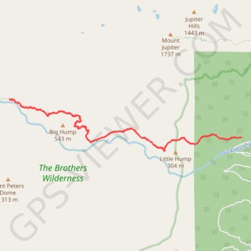
Name: Five Mile Camp via Duckabush Trail in the The Brothers Wilderness trail, distance, elevation, map, profile, GPS track
End: Duckabush Trail #803, Jefferson County, Washington, United States (47.69279 -123.10900)
Coordinates: 47.68234 -123.10900 47.69279 -123.03977