Tam McArthur Rim Trail in Deschutes National Forest
The Tam McArthur Rim Trail offers a remarkable hiking experience with stunning views of the Cascade Mountains, including iconic peaks such as Mount Bachelor, Broken Top, and the Three Sisters. As hikers ascend, they enjoy sweeping vistas over Three Creeks Lake, surrounded by rugged cliffs and the volcanic landscape of the area. The final stretch of the trail rewards adventurers with panoramic views, where cliffs drop away on three sides, and the surrounding terrain showcases a blend of alpine meadows, rocky outcrops, and distant snow-capped peaks. #Hiking #Mountain #Forest #Nature #Lake #Cliff
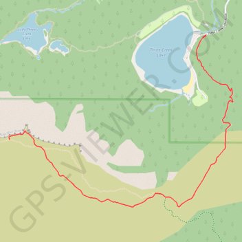
- Distance: 8.6 Km
- Elevation gain: 387 m
- Maximum elevation: 2,357 m
- Elevation loss: 386 m
- Minimum elevation: 1,993 m
Interactive trail map
Trail profile
About this trail
Name: Tam McArthur Rim Trail in Deschutes National Forest trail, distance, elevation, map, profile, GPS track
Start: Tam McArthur Rim Trail #4078, Deschutes County, Oregon, United States (44.10075 -121.62245)
End: Tam McArthur Rim Trail #4078, Deschutes County, Oregon, United States (44.10070 -121.62253)
Coordinates: 44.08622 -121.64568 44.10075 -121.61932
Other hiking, mountain biking, running and outdoor activity trails
Click on a trail to view its statistics, map and profile.
Northern part of the Pacific Crest Trail (PCT)
United States > Oregon > Klamath County
Hike on the Pacific Crest National Scenic Trail from Crater Lake to Canada Border through Oregon and Washington along the Sierra Nevada and Cascade mountain ranges. #Hiking #Mountain #SierraNevada #Cascade #Nature #Forest #Park #PCT
Distance: 1,198.3 Km • Elevation gain: 44,308 m • Maximum elevation: 2,307 m