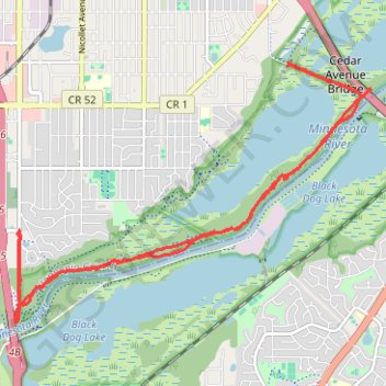
Bike Ride on Minnesota Valley State Trail
- Distance: 18.7 Km
- Elevation gain: 101 m
- Maximum elevation: 247 m
- Elevation loss: 105 m
- Minimum elevation: 212 m
Interactive trail map
Trail profile
- Distance: 18.7 Km
- Elevation gain: 101 m
- Maximum elevation: 247 m
- Elevation loss: 105 m
- Minimum elevation: 212 m
About this trail
Name: Bike Ride on Minnesota Valley State Trail trail, distance, elevation, map, profile, GPS track
Coordinates: 44.80101 -93.28942 44.83122 -93.23136
Other hiking, mountain biking, running and outdoor activity trails
Click on a trail to view its statistics, map and profile.
Fort Snelling State Park Minnesota River Greenway Loop
United States > Minnesota > Hennepin County > Bloomington
Distance: 15.9 Km • Elevation gain: 118 m • Maximum elevation: 252 m
Minnesota Valley National Wildlife Refuge Hiking - Bass Ponds to Old Cedar Ave bridge
United States > Minnesota > Hennepin County > Bloomington
Distance: 6.1 Km • Elevation gain: 63 m • Maximum elevation: 245 m