Red Pine Lake
Interactive trail map
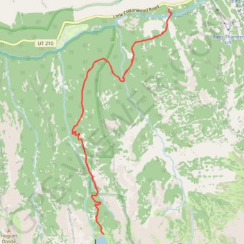
Trail profile
- Distance: 11.3 Km
- Elevation gain: 653 m
- Maximum elevation: 2,938 m
- Elevation loss: 653 m
- Minimum elevation: 2,335 m
About this trail
Name: Red Pine Lake trail, distance, elevation, map, profile, GPS track
Start: White Pine Trail, Salt Lake County, Utah, 84138, United States (40.57537 -111.68126)
End: White Pine Trail, Salt Lake County, Utah, 84138, United States (40.57538 -111.68122)
Coordinates: 40.54464 -111.69849 40.57538 -111.68078
Other hiking, mountain biking, running and outdoor activity trails
Click on a trail to view its statistics, map and profile.
Gloria Falls
United States > Utah > Salt Lake County
The hike to Gloria Falls takes you through a peaceful forest setting, following a well-trodden trail along a creek, with beautiful views of surrounding ridges. Though some sections are a bit rocky, the gradual incline makes it accessible for most hikers, including beginners. At the end, the trail rewards you…
Distance: 4.3 Km • Elevation gain: 197 m • Maximum elevation: 2,517 m