Thank you for supporting this site ❤️
Make a donation
Make a donation
Gear up for your next adventure:
As an Amazon Associate, this site earns from qualifying purchases at no extra cost to you.
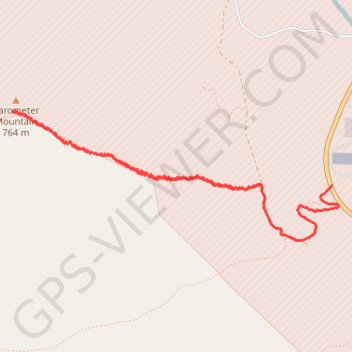
Barometer Mountain
- Distance: 4.6 Km
- Elevation gain: 731 m
- Maximum elevation: 750 m
- Elevation loss: 680 m
- Minimum elevation: 28 m
- Moving time: 2 h 14 m
- Moving speed: 2.1 Km/h
- Maximum speed: 7.4 Km/h
- Total time: 4 h 26 m
- Global speed: 1.0 Km/h
Interactive trail map
Thank you for supporting this site ❤️
Make a donation
Make a donation
Gear up for your next adventure:
As an Amazon Associate, this site earns from qualifying purchases at no extra cost to you.
Trail profile
- Distance: 4.6 Km
- Elevation gain: 731 m
- Maximum elevation: 750 m
- Elevation loss: 680 m
- Minimum elevation: 28 m
- Moving time: 2 h 14 m
- Moving speed: 2.1 Km/h
- Maximum speed: 7.4 Km/h
- Total time: 4 h 26 m
- Global speed: 1.0 Km/h
Thank you for supporting this site ❤️
Make a donation
Make a donation
Gear up for your next adventure:
As an Amazon Associate, this site earns from qualifying purchases at no extra cost to you.
About this trail
Name: Barometer Mountain trail, distance, elevation, map, profile, GPS track
Start: Rezanof Drive West, Aviation Hill, Kodiak Island, Alaska, 99619, United States (57.75079 -152.51911)
End: Burma Road, Kodiak Island, Alaska, 99619, United States (57.75089 -152.52564)
Coordinates: 57.74811 -152.54845 57.75446 -152.51850
Thank you for supporting this site ❤️
Make a donation
Make a donation
Gear up for your next adventure:
As an Amazon Associate, this site earns from qualifying purchases at no extra cost to you.