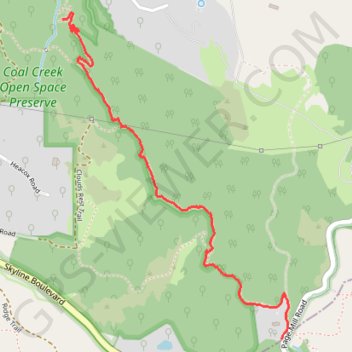
Alpine Trail, in and near Coal Creek Open Space Preserve, San Mateo Cty, CA
- Distance: 2.6 Km
- Elevation gain: 11 m
- Maximum elevation: 659 m
- Elevation loss: 182 m
- Minimum elevation: 485 m
- Moving time: 41 m 22 s
- Moving speed: 3.8 Km/h
- Maximum speed: 6.8 Km/h
- Total time: 44 m 59 s
- Global speed: 3.5 Km/h
Interactive trail map
Trail profile
- Distance: 2.6 Km
- Elevation gain: 11 m
- Maximum elevation: 659 m
- Elevation loss: 182 m
- Minimum elevation: 485 m
- Moving time: 41 m 22 s
- Moving speed: 3.8 Km/h
- Maximum speed: 6.8 Km/h
- Total time: 44 m 59 s
- Global speed: 3.5 Km/h
About this trail
Name: Alpine Trail, in and near Coal Creek Open Space Preserve, San Mateo Cty, CA trail, distance, elevation, map, profile, GPS track
Start: Page Mill Road, Palo Alto, San Mateo County, California, United States (37.32093 -122.18892)
End: Alpine Road Trail, San Mateo County, California, United States (37.33371 -122.19994)
Coordinates: 37.32093 -122.19994 37.33396 -122.18855