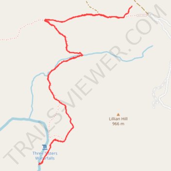
Three Sisters Falls Trail in Cleveland National Forest
The Three Sisters Falls Trail in Cleveland National Forest offers hikers a challenging yet rewarding journey through diverse landscapes. The path descends into a rugged canyon, providing expansive views of the surrounding mountains and the Boulder Creek valley. Upon reaching the falls, hikers are greeted by the sight of three cascading waterfalls nestled among smooth granite boulders, creating a serene and picturesque setting. #Hiking #Canyon #Forest #Nature #Waterfall
- Distance: 6.3 Km
- Elevation gain: 295 m
- Maximum elevation: 889 m
- Elevation loss: 295 m
- Minimum elevation: 634 m
- Moving time: 1 h 30 m
- Moving speed: 4.2 Km/h
- Maximum speed: 8.9 Km/h
- Total time: 1 h 39 m
- Global speed: 3.8 Km/h
Interactive trail map
Trail profile
- Distance: 6.3 Km
- Elevation gain: 295 m
- Maximum elevation: 889 m
- Elevation loss: 295 m
- Minimum elevation: 634 m
- Moving time: 1 h 30 m
- Moving speed: 4.2 Km/h
- Maximum speed: 8.9 Km/h
- Total time: 1 h 39 m
- Global speed: 3.8 Km/h
About this trail
Name: Three Sisters Falls Trail in Cleveland National Forest trail, distance, elevation, map, profile, GPS track
Start: Cedar Creek Road, San Diego County, California, United States (32.98526 -116.67890)
End: Cedar Creek Road, San Diego County, California, United States (32.98531 -116.67887)
Coordinates: 32.97149 -116.68856 32.98531 -116.67887
Other hiking, mountain biking, running and outdoor activity trails
Click on a trail to view its statistics, map and profile.