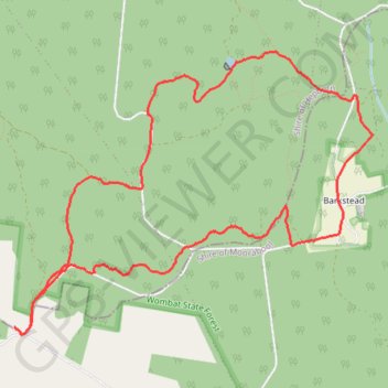
Mollonghip-Barkstead, Wombat State Forest, Circuit
- Distance: 11.1 Km
- Elevation gain: 170 m
- Maximum elevation: 710 m
- Elevation loss: 170 m
- Minimum elevation: 626 m
- Moving time: 2 h 27 m
- Moving speed: 4.5 Km/h
- Maximum speed: 7.5 Km/h
- Total time: 3 h 2 m
- Global speed: 3.6 Km/h
Interactive trail map
Trail profile
- Distance: 11.1 Km
- Elevation gain: 170 m
- Maximum elevation: 710 m
- Elevation loss: 170 m
- Minimum elevation: 626 m
- Moving time: 2 h 27 m
- Moving speed: 4.5 Km/h
- Maximum speed: 7.5 Km/h
- Total time: 3 h 2 m
- Global speed: 3.6 Km/h
About this trail
Name: Mollonghip-Barkstead, Wombat State Forest, Circuit trail, distance, elevation, map, profile, GPS track
Start: Goldfields Track, Mollongghip, Shire of Hepburn, Victoria, Australia (-37.46958 144.05439)
End: Goldfields Track, Mollongghip, Shire of Hepburn, Victoria, Australia (-37.46955 144.05433)
Coordinates: -37.47014 144.05433 -37.44804 144.08962