Make a donation
Gear up for your next adventure:
As an Amazon Associate, this site earns from qualifying purchases at no extra cost to you.
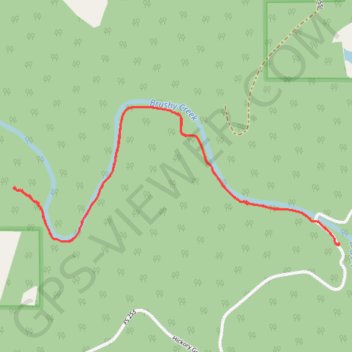
Sougahoagdee Falls Trail in William B. Bankhead National Forest
The Sougahoagdee Falls Trail is a relatively easy-to-follow route that leads to a tranquil and scenic waterfall. The path is mostly flat, following Brushy Creek and passing through diverse forest landscapes, with a few small waterfalls along the way. The main highlight is Sougahoagdee Falls, which offers a peaceful view, with a soft, trickling water sound and moss-covered rocks around the falls, making it a great spot for photos or simply relaxing in nature. #Hiking #Waterfall #River #Forest #Nature
- Distance: 5.5 Km
- Elevation gain: 109 m
- Maximum elevation: 204 m
- Elevation loss: 107 m
- Minimum elevation: 176 m
- Moving time: 1 h 34 m
- Moving speed: 3.5 Km/h
- Maximum speed: 5.8 Km/h
- Total time: 1 h 58 m
- Global speed: 2.8 Km/h
Interactive trail map
Make a donation
Gear up for your next adventure:
As an Amazon Associate, this site earns from qualifying purchases at no extra cost to you.
Trail profile
- Distance: 5.5 Km
- Elevation gain: 109 m
- Maximum elevation: 204 m
- Elevation loss: 107 m
- Minimum elevation: 176 m
- Moving time: 1 h 34 m
- Moving speed: 3.5 Km/h
- Maximum speed: 5.8 Km/h
- Total time: 1 h 58 m
- Global speed: 2.8 Km/h
Make a donation
Gear up for your next adventure:
As an Amazon Associate, this site earns from qualifying purchases at no extra cost to you.
About this trail
Name: Sougahoagdee Falls Trail in William B. Bankhead National Forest trail, distance, elevation, map, profile, GPS track
Start: 1595, Hickory Grove Road, Winston County, Alabama, 35572, United States (34.25139 -87.24599)
End: 1596, Hickory Grove Road, Winston County, Alabama, 35572, United States (34.25154 -87.24624)
Coordinates: 34.25126 -87.26473 34.25785 -87.24598
Make a donation
Gear up for your next adventure:
As an Amazon Associate, this site earns from qualifying purchases at no extra cost to you.