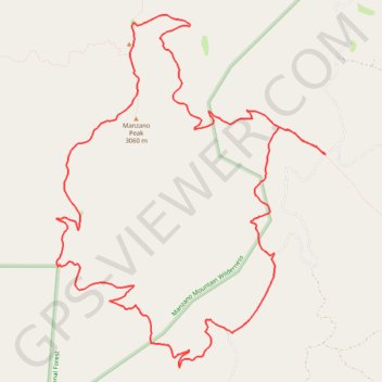
Manzano Peak Loop via Cottonwood Trail, Pine Shadow Trail and Kayser Mill Trail
- Distance: 19.0 Km
- Elevation gain: 977 m
- Maximum elevation: 3,022 m
- Elevation loss: 977 m
- Minimum elevation: 2,199 m
- Moving time: 5 h 31 m
- Moving speed: 3.4 Km/h
- Maximum speed: 6.2 Km/h
- Total time: 6 h 37 m
- Global speed: 2.9 Km/h
Interactive trail map
Trail profile
- Distance: 19.0 Km
- Elevation gain: 977 m
- Maximum elevation: 3,022 m
- Elevation loss: 977 m
- Minimum elevation: 2,199 m
- Moving time: 5 h 31 m
- Moving speed: 3.4 Km/h
- Maximum speed: 6.2 Km/h
- Total time: 6 h 37 m
- Global speed: 2.9 Km/h
About this trail
Name: Manzano Peak Loop via Cottonwood Trail, Pine Shadow Trail and Kayser Mill Trail trail, distance, elevation, map, profile, GPS track
Start: Forest 422 Road, Torrance County, New Mexico, United States (34.58701 -106.42116)
Coordinates: 34.56324 -106.45771 34.60272 -106.42116