Make a donation
Gear up for your next adventure:
As an Amazon Associate, this site earns from qualifying purchases at no extra cost to you.
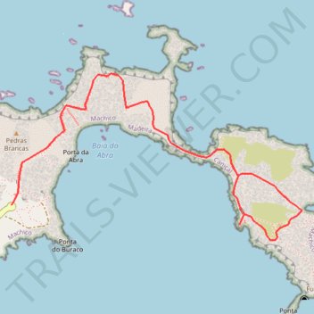
La Ponta de Sao Lourenço
https://en-bw.trails-viewer.com/trail-n8lm2/La-Ponta-de-Sao-Lourenço/
- Distance: 6.6 Km
- Elevation gain: 591 m
- Maximum elevation: 102 m
- Elevation loss: 591 m
- Minimum elevation: -1 m
Interactive trail map
Make a donation
Gear up for your next adventure:
As an Amazon Associate, this site earns from qualifying purchases at no extra cost to you.
Trail profile
- Distance: 6.6 Km
- Elevation gain: 591 m
- Maximum elevation: 102 m
- Elevation loss: 591 m
- Minimum elevation: -1 m
Make a donation
Gear up for your next adventure:
As an Amazon Associate, this site earns from qualifying purchases at no extra cost to you.
About this trail
Name: La Ponta de Sao Lourenço trail, distance, elevation, map, profile, GPS track
Start: Rotunda da Ponta de São Lourenço, Caniçal, Machico, Madeira, 9200-044, Portugal (32.74322 -16.70105)
End: Rotunda da Ponta de São Lourenço, Caniçal, Machico, Madeira, 9200-044, Portugal (32.74322 -16.70105)
Coordinates: 32.74129 -16.70105 32.75051 -16.68193
Make a donation
Gear up for your next adventure:
As an Amazon Associate, this site earns from qualifying purchases at no extra cost to you.
Other hiking, mountain biking, running and outdoor activity trails
Click on a trail to view its statistics, map and profile.
La Ponta de Sao Lourenço
Distance: 6.6 Km • Elevation gain: 592 m • Maximum elevation: 102 m