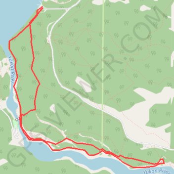
Import a GPX file

Miles Canyon Loop

Yukon River. #Hiking #Loop #Yukon

  • Distance: 6.3 Km
  • Elevation gain: 100 m
  • Maximum elevation: 688 m
  • Elevation loss: 99 m
  • Minimum elevation: 653 m

Interactive trail map

Trail profile

  • Distance: 6.3 Km
  • Elevation gain: 100 m
  • Maximum elevation: 688 m
  • Elevation loss: 99 m
  • Minimum elevation: 653 m

About this trail

Name: Miles Canyon Loop trail, distance, elevation, map, profile, GPS track

Start: Chadburn Lake Road, Whitehorse, Yukon, Y1A 5V9, Canada (60.67264 -135.02425)

End: Chadburn Lake Road, Whitehorse, Yukon, Y1A 5V9, Canada (60.67252 -135.02418)

Coordinates: 60.65775 -135.03051 60.67264 -135.00120

Topography: Whitehorse topographic map, elevation, terrain

Gear up for your next adventure:

🔋Emergency Crank Radio - Weather alerts and power without needing batteries
🧦Thermal Socks - Warm socks for winter hiking or camping
🧢Outdoor Visor - Breathable visor for sunny hikes
🧥Softshell Jacket - Windproof and breathable jacket for hiking
🐕Hiking Dog Pack - Let your canine companion carry their own water and food

As an Amazon Associate, this site earns from qualifying purchases at no extra cost to you.