Make a donation
Gear up for your next adventure:
As an Amazon Associate, this site earns from qualifying purchases at no extra cost to you.
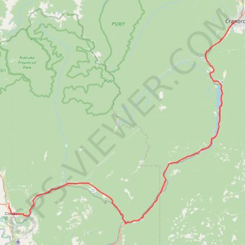
Creston - Cranbrook
Interactive trail map
Make a donation
Gear up for your next adventure:
As an Amazon Associate, this site earns from qualifying purchases at no extra cost to you.
Trail profile
- Distance: 107.1 Km
- Elevation gain: 1,009 m
- Maximum elevation: 1,003 m
- Elevation loss: 679 m
- Minimum elevation: 590 m
Make a donation
Gear up for your next adventure:
As an Amazon Associate, this site earns from qualifying purchases at no extra cost to you.
About this trail
Name: Creston - Cranbrook trail, distance, elevation, map, profile, GPS track
Coordinates: 49.07500 -116.52355 49.50859 -115.77597
Topography: Regional District of Central Kootenay topographic map, elevation, terrain
Make a donation
Gear up for your next adventure:
As an Amazon Associate, this site earns from qualifying purchases at no extra cost to you.
Other hiking, mountain biking, running and outdoor activity trails
Click on a trail to view its statistics, map and profile.
Crawford Bay - Creston
Canada > British Columbia > Regional District of Central Kootenay > Area A (Wynndel/Crawford Bay/Riondel) > Crawford Bay
Kootenay Lake. #Bike
Distance: 76.8 Km • Elevation gain: 1,016 m • Maximum elevation: 681 m