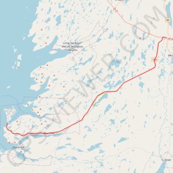
Argentia - Whitbourne
- Distance: 45.9 Km
- Elevation gain: 453 m
- Maximum elevation: 183 m
- Elevation loss: 401 m
- Minimum elevation: 0 m
Interactive trail map
Trail profile
- Distance: 45.9 Km
- Elevation gain: 453 m
- Maximum elevation: 183 m
- Elevation loss: 401 m
- Minimum elevation: 0 m
About this trail
Name: Argentia - Whitbourne trail, distance, elevation, map, profile, GPS track
Coordinates: 47.26436 -53.99626 47.45021 -53.55219
Topography: Newfoundland and Labrador topographic map, elevation, terrain
Other hiking, mountain biking, running and outdoor activity trails
Click on a trail to view its statistics, map and profile.
Whitbourne - St. John's
Canada > Newfoundland and Labrador > Whitbourne
#Bike #Whitbourne #StJohns #Newfoundland #Atlantic
Distance: 103.3 Km • Elevation gain: 1,230 m • Maximum elevation: 234 m
Arnold's Cove - Whitbourne
Canada > Newfoundland and Labrador
#Bike #ArnoldsCove #Whitbourne #Newfoundland
Distance: 50.5 Km • Elevation gain: 719 m • Maximum elevation: 199 m