Thank you for supporting this site ❤️
Make a donation
Make a donation
Gear up for your next adventure:
As an Amazon Associate, this site earns from qualifying purchases at no extra cost to you.
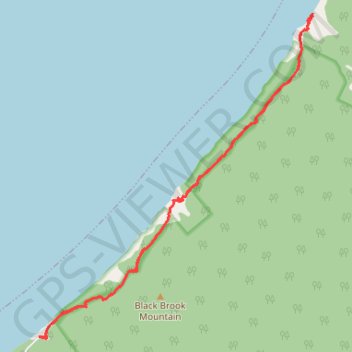
Cape Breton Island - Pollets Cove
Gulf of Saint Lawrence. #Hiking #CapeBreton #SaintLawrence #Atlantic
- Distance: 13.9 Km
- Elevation gain: 876 m
- Maximum elevation: 213 m
- Elevation loss: 875 m
- Minimum elevation: 0 m
Interactive trail map
Thank you for supporting this site ❤️
Make a donation
Make a donation
Gear up for your next adventure:
As an Amazon Associate, this site earns from qualifying purchases at no extra cost to you.
Trail profile
- Distance: 13.9 Km
- Elevation gain: 876 m
- Maximum elevation: 213 m
- Elevation loss: 875 m
- Minimum elevation: 0 m
Thank you for supporting this site ❤️
Make a donation
Make a donation
Gear up for your next adventure:
As an Amazon Associate, this site earns from qualifying purchases at no extra cost to you.
About this trail
Name: Cape Breton Island - Pollets Cove trail, distance, elevation, map, profile, GPS track
Coordinates: 46.87289 -60.74307 46.91432 -60.69208
Topography: Municipality of the County of Inverness topographic map, elevation, terrain
Thank you for supporting this site ❤️
Make a donation
Make a donation
Gear up for your next adventure:
As an Amazon Associate, this site earns from qualifying purchases at no extra cost to you.