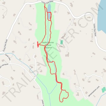
Halle Ravine Nature Preserve and Pine Terrace Preserve loop trails
- Distance: 2.9 Km
- Elevation gain: 69 m
- Maximum elevation: 171 m
- Elevation loss: 69 m
- Minimum elevation: 128 m
- Moving time: 42 m 20 s
- Moving speed: 4.1 Km/h
- Maximum speed: 7.7 Km/h
- Total time: 44 m 35 s
- Global speed: 3.9 Km/h
Interactive trail map
Trail profile
- Distance: 2.9 Km
- Elevation gain: 69 m
- Maximum elevation: 171 m
- Elevation loss: 69 m
- Minimum elevation: 128 m
- Moving time: 42 m 20 s
- Moving speed: 4.1 Km/h
- Maximum speed: 7.7 Km/h
- Total time: 44 m 35 s
- Global speed: 3.9 Km/h
About this trail
Name: Halle Ravine Nature Preserve and Pine Terrace Preserve loop trails trail, distance, elevation, map, profile, GPS track
Coordinates: 41.20800 -73.56334 41.21686 -73.55963
Other hiking, mountain biking, running and outdoor activity trails
Click on a trail to view its statistics, map and profile.