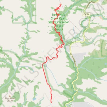
La Honda Creek Open Space - Harrington Creek Trail and Lonely Forest Trail
- Distance: 11.8 Km
- Elevation gain: 458 m
- Maximum elevation: 351 m
- Elevation loss: 457 m
- Minimum elevation: 209 m
- Moving time: 2 h 49 m
- Moving speed: 4.2 Km/h
- Maximum speed: 46.8 Km/h
- Total time: 3 h 9 m
- Global speed: 3.7 Km/h
Interactive trail map
Trail profile
- Distance: 11.8 Km
- Elevation gain: 458 m
- Maximum elevation: 351 m
- Elevation loss: 457 m
- Minimum elevation: 209 m
- Moving time: 2 h 49 m
- Moving speed: 4.2 Km/h
- Maximum speed: 46.8 Km/h
- Total time: 3 h 9 m
- Global speed: 3.7 Km/h
About this trail
Name: La Honda Creek Open Space - Harrington Creek Trail and Lonely Forest Trail trail, distance, elevation, map, profile, GPS track
Coordinates: 37.32622 -122.28358 37.35881 -122.27458