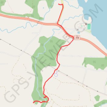
Bonnel Falls
- Distance: 3.8 Km
- Elevation gain: 83 m
- Maximum elevation: 128 m
- Elevation loss: 174 m
- Minimum elevation: 4 m
- Moving time: 34 m 42 s
- Moving speed: 6.6 Km/h
- Maximum speed: 61.0 Km/h
- Total time: 54 m 50 s
- Global speed: 4.2 Km/h
Interactive trail map
Trail profile
- Distance: 3.8 Km
- Elevation gain: 83 m
- Maximum elevation: 128 m
- Elevation loss: 174 m
- Minimum elevation: 4 m
- Moving time: 34 m 42 s
- Moving speed: 6.6 Km/h
- Maximum speed: 61.0 Km/h
- Total time: 54 m 50 s
- Global speed: 4.2 Km/h
About this trail
Name: Bonnel Falls trail, distance, elevation, map, profile, GPS track
Coordinates: 49.24757 -124.20702 49.26775 -124.19447
Topography: Area E (Nanoose Bay) topographic map, elevation, terrain
Other hiking, mountain biking, running and outdoor activity trails
Click on a trail to view its statistics, map and profile.
Sproat Lake - Nanaimo
Canada > British Columbia > Alberni-Clayoquot Regional District > Area D (Sproat Lake)
Distance: 87.0 Km • Elevation gain: 1,273 m • Maximum elevation: 422 m