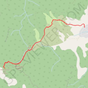
2021-02-21 17:38:06
- Distance: 10.8 Km
- Elevation gain: 673 m
- Maximum elevation: 1,148 m
- Elevation loss: 673 m
- Minimum elevation: 484 m
- Moving time: 3 h 7 m
- Moving speed: 3.5 Km/h
- Maximum speed: 6.3 Km/h
- Total time: 3 h 23 m
- Global speed: 3.2 Km/h
Interactive trail map
Trail profile
- Distance: 10.8 Km
- Elevation gain: 673 m
- Maximum elevation: 1,148 m
- Elevation loss: 673 m
- Minimum elevation: 484 m
- Moving time: 3 h 7 m
- Moving speed: 3.5 Km/h
- Maximum speed: 6.3 Km/h
- Total time: 3 h 23 m
- Global speed: 3.2 Km/h
About this trail
Name: 2021-02-21 17:38:06 trail, distance, elevation, map, profile, GPS track
Coordinates: 43.72894 22.16096 43.74797 22.20495