Thank you for supporting this site ❤️
Make a donation
Make a donation
Gear up for your next adventure:
As an Amazon Associate, this site earns from qualifying purchases at no extra cost to you.
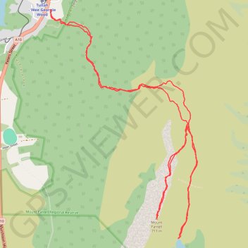
Mount Farrell - Lake Herbert
Interactive trail map
Thank you for supporting this site ❤️
Make a donation
Make a donation
Gear up for your next adventure:
As an Amazon Associate, this site earns from qualifying purchases at no extra cost to you.
Trail profile
- Distance: 9.9 Km
- Elevation gain: 582 m
- Maximum elevation: 682 m
- Elevation loss: 582 m
- Minimum elevation: 184 m
- Moving time: 3 h 17 m
- Moving speed: 3.0 Km/h
- Maximum speed: 8.6 Km/h
- Total time: 4 h 3 m
- Global speed: 2.4 Km/h
Thank you for supporting this site ❤️
Make a donation
Make a donation
Gear up for your next adventure:
As an Amazon Associate, this site earns from qualifying purchases at no extra cost to you.
About this trail
Name: Mount Farrell - Lake Herbert trail, distance, elevation, map, profile, GPS track
End: Mt Farell walking track, Tullah, West Coast, Tasmania, 7321, Australia (-41.73060 145.62496)
Coordinates: -41.75104 145.62493 -41.73060 145.64246
Thank you for supporting this site ❤️
Make a donation
Make a donation
Gear up for your next adventure:
As an Amazon Associate, this site earns from qualifying purchases at no extra cost to you.