Make a donation
Gear up for your next adventure:
As an Amazon Associate, this site earns from qualifying purchases at no extra cost to you.
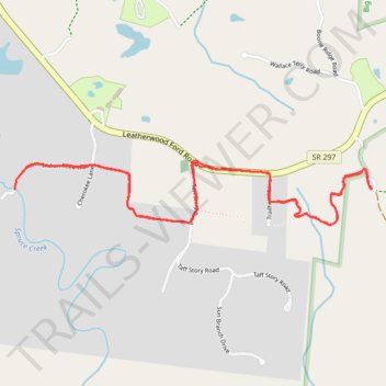
Spruce Creek Trail
- Distance: 6.1 Km
- Elevation gain: 103 m
- Maximum elevation: 481 m
- Elevation loss: 103 m
- Minimum elevation: 443 m
Interactive trail map
Make a donation
Gear up for your next adventure:
As an Amazon Associate, this site earns from qualifying purchases at no extra cost to you.
Trail profile
- Distance: 6.1 Km
- Elevation gain: 103 m
- Maximum elevation: 481 m
- Elevation loss: 103 m
- Minimum elevation: 443 m
Make a donation
Gear up for your next adventure:
As an Amazon Associate, this site earns from qualifying purchases at no extra cost to you.
About this trail
Name: Spruce Creek Trail trail, distance, elevation, map, profile, GPS track
Start: Fentress County, Middle Tennessee, Tennessee, United States (36.47263 -84.75151)
Coordinates: 36.47067 -84.77175 36.47362 -84.75136
Make a donation
Gear up for your next adventure:
As an Amazon Associate, this site earns from qualifying purchases at no extra cost to you.
Other hiking, mountain biking, running and outdoor activity trails
Click on a trail to view its statistics, map and profile.
Cumberland Valley Loop Trail
United States > Tennessee > Fentress County
Fentress County Dia
Distance: 29.3 Km • Elevation gain: 513 m • Maximum elevation: 485 m