Thank you for supporting this site ❤️
Make a donation
Make a donation
Gear up for your next adventure:
As an Amazon Associate, this site earns from qualifying purchases at no extra cost to you.
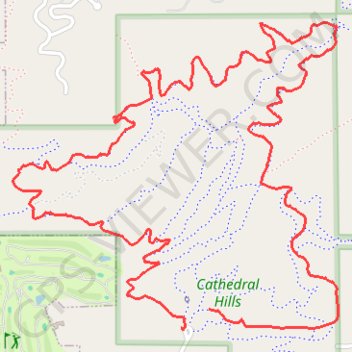
Cathedral Hills
- Distance: 6.4 Km
- Elevation gain: 227 m
- Maximum elevation: 455 m
- Elevation loss: 232 m
- Minimum elevation: 347 m
- Moving time: 51 m 13 s
- Moving speed: 7.5 Km/h
- Maximum speed: 19.9 Km/h
- Total time: 54 m 20 s
- Global speed: 7.1 Km/h
Interactive trail map
Thank you for supporting this site ❤️
Make a donation
Make a donation
Gear up for your next adventure:
As an Amazon Associate, this site earns from qualifying purchases at no extra cost to you.
Trail profile
- Distance: 6.4 Km
- Elevation gain: 227 m
- Maximum elevation: 455 m
- Elevation loss: 232 m
- Minimum elevation: 347 m
- Moving time: 51 m 13 s
- Moving speed: 7.5 Km/h
- Maximum speed: 19.9 Km/h
- Total time: 54 m 20 s
- Global speed: 7.1 Km/h
Thank you for supporting this site ❤️
Make a donation
Make a donation
Gear up for your next adventure:
As an Amazon Associate, this site earns from qualifying purchases at no extra cost to you.
About this trail
Name: Cathedral Hills trail, distance, elevation, map, profile, GPS track
Start: Backside Loop Trail, Josephine County, Oregon, 97527, United States (42.39462 -123.33268)
Coordinates: 42.39395 -123.34145 42.40409 -123.32693
Thank you for supporting this site ❤️
Make a donation
Make a donation
Gear up for your next adventure:
As an Amazon Associate, this site earns from qualifying purchases at no extra cost to you.