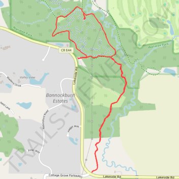
Wanatee Park
- Distance: 5.6 Km
- Elevation gain: 86 m
- Maximum elevation: 269 m
- Elevation loss: 87 m
- Minimum elevation: 232 m
- Moving time: 1 h 12 m
- Moving speed: 4.7 Km/h
- Maximum speed: 6.9 Km/h
- Total time: 1 h 31 m
- Global speed: 3.7 Km/h
Interactive trail map
Trail profile
- Distance: 5.6 Km
- Elevation gain: 86 m
- Maximum elevation: 269 m
- Elevation loss: 87 m
- Minimum elevation: 232 m
- Moving time: 1 h 12 m
- Moving speed: 4.7 Km/h
- Maximum speed: 6.9 Km/h
- Total time: 1 h 31 m
- Global speed: 3.7 Km/h
About this trail
Name: Wanatee Park trail, distance, elevation, map, profile, GPS track
Start: Multi-Use Trail, Linn County, Iowa, 39198, United States (42.00238 -91.56515)
End: Multi-Use Trail, Linn County, Iowa, 39198, United States (42.00240 -91.56521)
Coordinates: 41.99111 -91.56856 42.00746 -91.55871