Thank you for supporting this site ❤️
Make a donation
Make a donation
Gear up for your next adventure:
As an Amazon Associate, this site earns from qualifying purchases at no extra cost to you.
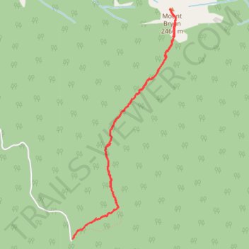
Mount Bryan trail
- Distance: 6.7 Km
- Elevation gain: 940 m
- Maximum elevation: 2,479 m
- Elevation loss: 941 m
- Minimum elevation: 1,548 m
- Moving time: 2 h 26 m
- Moving speed: 2.7 Km/h
- Maximum speed: 8.2 Km/h
- Total time: 5 h 23 m
- Global speed: 1.2 Km/h
Interactive trail map
Thank you for supporting this site ❤️
Make a donation
Make a donation
Gear up for your next adventure:
As an Amazon Associate, this site earns from qualifying purchases at no extra cost to you.
Trail profile
- Distance: 6.7 Km
- Elevation gain: 940 m
- Maximum elevation: 2,479 m
- Elevation loss: 941 m
- Minimum elevation: 1,548 m
- Moving time: 2 h 26 m
- Moving speed: 2.7 Km/h
- Maximum speed: 8.2 Km/h
- Total time: 5 h 23 m
- Global speed: 1.2 Km/h
Thank you for supporting this site ❤️
Make a donation
Make a donation
Gear up for your next adventure:
As an Amazon Associate, this site earns from qualifying purchases at no extra cost to you.
About this trail
Name: Mount Bryan trail trail, distance, elevation, map, profile, GPS track
Coordinates: 50.48155 -115.84727 50.50133 -115.83337
Topography: Area F (Columbia Lake/Windermere Lake) topographic map, elevation, terrain
Thank you for supporting this site ❤️
Make a donation
Make a donation
Gear up for your next adventure:
As an Amazon Associate, this site earns from qualifying purchases at no extra cost to you.