Make a donation
Gear up for your next adventure:
As an Amazon Associate, this site earns from qualifying purchases at no extra cost to you.
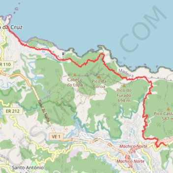
Vereda do Larano and Levada do Caniçal
- Distance: 12.5 Km
- Elevation gain: 958 m
- Maximum elevation: 413 m
- Elevation loss: 1,165 m
- Minimum elevation: 0 m
Interactive trail map
Make a donation
Gear up for your next adventure:
As an Amazon Associate, this site earns from qualifying purchases at no extra cost to you.
Trail profile
- Distance: 12.5 Km
- Elevation gain: 958 m
- Maximum elevation: 413 m
- Elevation loss: 1,165 m
- Minimum elevation: 0 m
Make a donation
Gear up for your next adventure:
As an Amazon Associate, this site earns from qualifying purchases at no extra cost to you.
About this trail
Name: Vereda do Larano and Levada do Caniçal trail, distance, elevation, map, profile, GPS track
Start: Levada do Caniçal, Poço do Gil, Machico, Madeira, 9200-121, Portugal (32.73288 -16.76430)
Coordinates: 32.73234 -16.82779 32.77286 -16.76430
Make a donation
Gear up for your next adventure:
As an Amazon Associate, this site earns from qualifying purchases at no extra cost to you.
Other hiking, mountain biking, running and outdoor activity trails
Click on a trail to view its statistics, map and profile.
MIUT2020_115_training
Distance: 119.5 Km • Elevation gain: 10,113 m • Maximum elevation: 1,797 m
MIUT2023_115_training
Distance: 112.2 Km • Elevation gain: 9,384 m • Maximum elevation: 1,797 m
MIUT2020_115_training
Distance: 119.5 Km • Elevation gain: 10,113 m • Maximum elevation: 1,797 m