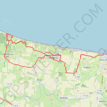
PortEnBessin Loop
- Distance: 24.7 Km
- Elevation gain: 279 m
- Maximum elevation: 78 m
- Elevation loss: 279 m
- Minimum elevation: 1 m
Interactive trail map
Trail profile
- Distance: 24.7 Km
- Elevation gain: 279 m
- Maximum elevation: 78 m
- Elevation loss: 279 m
- Minimum elevation: 1 m
About this trail
Name: PortEnBessin Loop trail, distance, elevation, map, profile, GPS track
Coordinates: 49.33701 -0.85547 49.36281 -0.75646
Other hiking, mountain biking, running and outdoor activity trails
Click on a trail to view its statistics, map and profile.
Bayeux boucle ouest longue
France > Normandy > Calvados > Bayeux
Distance: 74.6 Km • Elevation gain: 547 m • Maximum elevation: 76 m
PortEnBessin-Bayeux
France > Normandy > Calvados > Port-en-Bessin-Huppain
Distance: 17.5 Km • Elevation gain: 156 m • Maximum elevation: 67 m
Bayeux Boucle ouest courte
France > Normandy > Calvados > Bayeux
Distance: 56.8 Km • Elevation gain: 440 m • Maximum elevation: 76 m